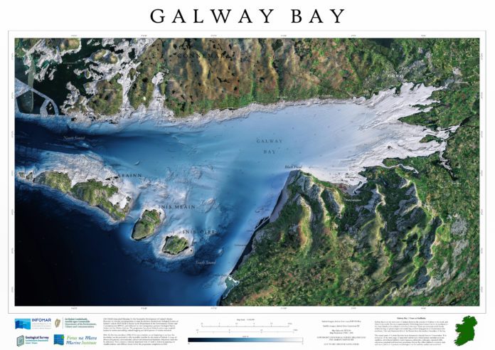
An incredible new map displays Galway Bay in never before seen levels of detail, including a clear picture of the land beneath the waves.
This is the first of the new Blue Scale map series of Ireland’s coastal waters, which contain unprecedented detail of the local topography, including the seabed.
This map has its origins in the INFOMAR seabed mapping programme which has been running since 2006.
They have been produced as a joint venture between the Marine Institute in Oranmore, and Geological Survey Ireland.
INFOMAR aims to map Ireland’s seabed and deliver a comprehensive baseline bathymetry dataset to underpin the future management of Ireland’s marine resource.
Galway Bay stretches for roughly 50km from Galway City at the mount of the River Corrib, out to the Aran Islands at the entrance to the bay in the west.
There are numerous small islands within the bay, of glacial origin in the inner bay, and low lying granite in Connemara to the northwest. The karst limestone hills of the Burren form the southern boundary of the bay.
The coastal parts of Galway Bay have been designated a Special Area of Conservation due to their wide range of important habitat types which include intertidal mud and sandflats, other littoral habitats, coastal lagoons, saltmarshes, turloughs, vegetated cliffs, calcareous grassland and limestone pavements.
Galway Bay offers habitat to common seals and otters, and is an important ornithological site for seabirds, waders and waterfowl.
INFOMAR is making all 18 maps available for free to the public to download in high resolution.
Follow the journey each week as a new map is released on the INFOMAR website, and join the conversation on Twitter, Instagram & Facebook.


